Facility and Site Location
Displaying the geographical location of a facility or site center on a SCADA screen.
EOS SCADA • MAP • MAP • USER CONTROL
MAP is a user control designed to embed map views into SCADA screens. It generates the map view centered on specified Latitude and Longitude values. The map presentation can be customized using properties such as map type, visibility, map features, zoom level, detail, brightness, and saturation.
The primary purpose of the MAP control is not to plot process data on a map, but to embed a configurable map view directly into a SCADA page. In the provided source code, the URL parameters for the map request are generated directly from the control's properties, after which the map image is retrieved.

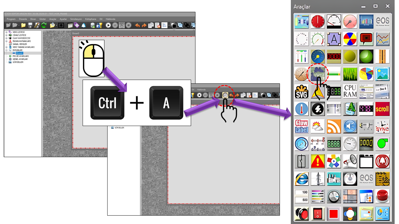
MAP is a visual user control used to add a map area directly to a SCADA screen design. An examination of the source code shows that the map request is constructed by combining the control's dimensions, center coordinates, map type, the appearance of specific map elements, visibility settings, zoom level, detail, brightness, and saturation.
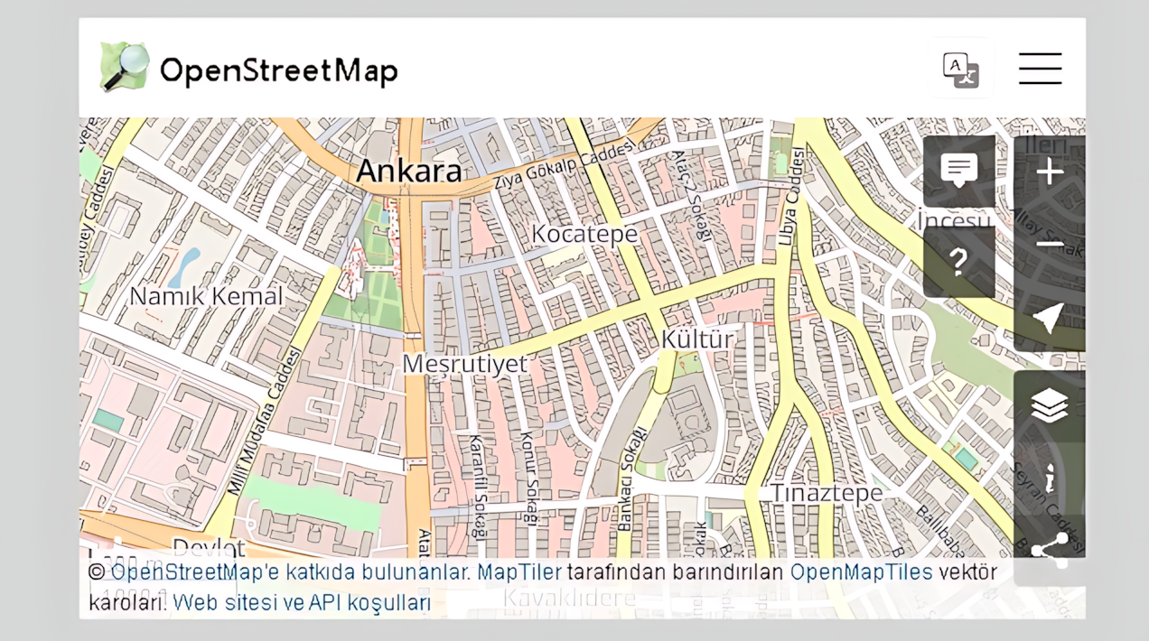
For this reason, the MAP control differs from a conventional data indicator. Instead of displaying a pointer, LED, bar, or numerical value, it presents a geographical image as a visual component of the SCADA page. The map center and visual details can be reconfigured through its properties.
Basic approach: The user specifies through the properties which location the map should center on and how it should appear. The control then builds a map request from these parameters and loads the map image.
The provided ProcessEkstraParamVals code clearly demonstrates
the relationship between the MAP control's properties and the map request.
The control dimensions, center coordinates, map type, and style/visibility
parameters are sequentially appended to MAPCOMMANDCALLSTR.
The source code calls the GETBINGMAP() method in the final step. Since the method body is not included in the provided code excerpt, the details of the underlying mechanism used to download or display the image have not been assumed on this page.
Control Size → Center → Map Type → Elements → Visibility → Zoom → Scale → Brightness → Saturation → GETBINGMAP()
In the source code, the query portion of the map URL is constructed step by step
in the MAPCOMMANDCALLSTR variable. Initially, the image dimensions
are determined using the control's actual width and height. The center, map type,
element styles, visibility settings, and image parameters are then added.
String mapstr = "http://maps.BINGapis.com/maps/api/staticmap?"
             + MAPCOMMANDCALLSTR
             + "&sensor=false";
As this structure shows, the MAP control is designed to retrieve the map image through a static map request. Since the URL query parameters are generated from the control properties, the same MAP control can be reused with different coordinates and display settings.
Service dependency: Retrieving the map image depends on the availability of the map service address defined in the source code. Since map service API addresses, authentication methods, and terms of use may change over time, the service address used in the application environment must be verified separately.
The Latitude and Longitude properties determine the geographical point at which the map is centered. In the source code, these two values are converted directly into the center parameter.
| Property | EOS Turkish Equivalent | Default | Description |
|---|---|---|---|
Latitude |
Latitude | 39 |
Determines the latitude of the map center. |
Longitude |
Longitude | 35 |
Determines the longitude of the map center. |
When Latitude = 39 and Longitude = 35, the source code sets the center of the map request to 39,35. The same two properties can be changed to display a different center for another facility, site, station, or geographical region.
MapType is the property that determines the map's basic visual type. Its default value in the source code is defined as Roadmap. Since the source does not provide all the options of the GNHaritaTuru type, this page describes only the verifiable default value.
| Property | EOS Turkish Equivalent | Default | Description |
|---|---|---|---|
MapType |
Map Type | Roadmap |
Determines the basic type of the map image. |
The map type should be considered together with the other visual properties. A road-focused view and a more visual or satellite-based view may present different levels of information density on the operator screen.
One notable feature of the MAP control is its ability to handle different map elements separately. The source code creates both element style and visibility parameters for six elements: roads, landscape, administrative features, POI, transit, and water.
| Property | EOS Turkish Equivalent | Default | Function in the Source Code |
|---|---|---|---|
MapItemRoad |
Map Element: Road | Geometry |
Determines the map component to which styling is applied for road elements. |
MapItemPeysaj |
Map Element: Landscape | Geometry |
Determines the styling component for landscape elements. |
MapItemAdministrative |
Map Element: Administrative | Geometry |
Determines the styling component for administrative elements. |
MapItemPOI |
Map Element: POI | Geometry |
Determines the styling component for points of interest. |
MapItemTransit |
Map Element: Transit | Geometry |
Determines the styling component for transit elements. |
MapItemWater |
Map Element: Water | Geometry |
Determines the styling component for water elements. |
In the source code, these properties are converted into query fragments in the form style=feature:.... This makes it possible to determine which visual elements affect the different components of the map image.
The visibility of map elements is managed through separate properties in the MAP control. An examination of the defaults in the source code shows that Off is used for roads, landscape, administrative features, POI, and transit, while On is used for water.
| Property | EOS Turkish Equivalent | Default | Description |
|---|---|---|---|
DisplayRoad |
Display Roads | Off |
Determines the visibility of road elements. |
DisplayPeysaj |
Display Landscape | Off |
Determines the visibility of landscape elements. |
DisplayAdministrative |
Display Administrative Features | Off |
Determines the visibility of administrative elements. |
DisplayPOI |
Display POI | Off |
Determines the visibility of POI elements. |
DisplayTransit |
Display Transit | Off |
Determines the visibility of transit elements. |
DisplayWater |
Display Water | On |
Determines the visibility of water elements. |
Visual simplification: Leaving visible only the map elements needed for the screen's purpose can improve map readability on information-dense SCADA screens.
In addition to the basic location and element settings, the map has four important display parameters: Map Zoom Factor, Map Detail Factor, Map Brightness, and Map Saturation. The source code adds all these values directly to the map request.
| Property | EOS Turkish Equivalent | Default | Role |
|---|---|---|---|
MapZoomFactor |
Map Zoom Factor | 4 |
Determines the map zoom level. |
MapDetailFactor |
Map Detail Factor | 1 |
Determines the detail/scale parameter of the map image. |
MapBrightness |
Map Brightness | 100 |
Adds the map's overall brightness value to the query. |
MapSaturation |
Map Saturation | 100 |
Adds the map's color saturation value to the query. |
If the map is used together with the main screen's background, brightness and saturation values can be adjusted to achieve visual consistency. If the map is the primary information source on a maintenance, site, or facility location screen, suitable zoom and detail settings can be selected.
In the source code, the map image dimensions are not assigned fixed values. Instead, they are obtained through MyWebBrowser.Width and MyWebBrowser.Height. This allows the request's size parameter to be generated according to the control's actual on-screen dimensions.
UpdateInterval is used to control the update timing. The code attempts to convert the value to an integer, falls back to 1000 if the value is invalid, and also prevents the update interval from dropping below the minimum permitted by the system. The timer interval is then set to this value.
| Property | EOS Turkish Equivalent | Default | Description |
|---|---|---|---|
UCType |
Control Type | MAP |
Defines the type of the user control. |
UpdateInterval |
Update Interval | 1000 ms |
The interval used to schedule control updates. |
DecimalPoint |
Decimal Places | 0 |
A numerical display setting maintained among the general user control parameters. |
UCBackColor |
Control Background Color | Transparent |
Determines the control's background color. |
UCForeColor |
Control Foreground Color | Black |
Determines the control's foreground/text color. |
UCFont |
Control Font | Arial Narrow, 8.25 pt |
Determines the control's base font. |
The provided ProcessEkstraParamVals method does more than read visual properties; it also reveals the MAP control's operational workflow.
DecimalPoint is missing, the default value 0 is added.Latitude + Longitude.MapType is added.GETBINGMAP().Source scope: The provided code excerpt does not show the contents of the GETBINGMAP(), UPDATEBAGLIDATA(), and SAKLAPARAMS() methods. Therefore, no additional behavior has been assumed regarding their internal algorithms beyond what is available in the source.
The MAP control can be considered for applications where displaying a map as part of a process screen is useful. It can be used to create a map area in designs where the geographical location of a site, facility, station, distribution point, or other location must be presented visually on the operator screen.
Displaying the geographical location of a facility or site center on a SCADA screen.
Adding a map area to screens containing facilities or stations distributed across different geographical locations.
Displaying a map on screens where road and surrounding-area information is useful alongside the facility location.
Creating operational, maintenance, or site information screens centered on specific coordinates.
The strength of the MAP control lies in the ability to reconfigure the same basic control for different screen purposes. The following examples illustrate how the properties in the source code can be considered together.
| Screen Purpose | Center | Visual Approach | Key Settings |
|---|---|---|---|
| Facility Location | Facility Latitude/Longitude | Simple road map | MapType, MapZoomFactor, DisplayRoad |
| Site View | Site Latitude/Longitude | Higher level of detail | MapZoomFactor, MapDetailFactor |
| Geographical Overview | Regional center | Wider area | MapZoomFactor, MapBrightness |
| Operations Screen | Operations center | Simple view with low visual density | DisplayRoad, DisplayPOI, DisplayTransit, MapSaturation |
The complete option lists for the GNHaritaTuru, GNHaritaBilesen, and GNGorunurlukTuru types used in the source code are not included in the provided material. Therefore, only the values explicitly visible in the source are documented below.
| Enumeration | Values Found in the Source | Where It Is Used |
|---|---|---|
GNHaritaTuru |
Roadmap |
MapType |
GNHaritaBilesen |
Geometry |
Six MapItem... properties |
GNGorunurlukTuru |
Off, On |
Six Display... properties |
The main properties defined in the MAP control's source code are listed below. Default values are taken directly from the provided C# definitions, while the Turkish equivalents are based on the mappings in the current terminology dictionary.
| Property | EOS Turkish Equivalent | Default | Purpose |
|---|---|---|---|
UCType |
Control Type | MAP |
Defines the type of the user control. |
UpdateInterval |
Update Interval | 1000 |
Used to schedule control updates. |
DecimalPoint |
Decimal Places | 0 |
A general numerical display parameter. |
UCBackColor |
Control Background Color | Transparent |
Determines the control's background color. |
UCForeColor |
Control Foreground Color | Black |
Determines the control's foreground/text color. |
UCFont |
Control Font | Arial Narrow, 8.25 pt |
Determines the control's base font. |
Latitude |
Latitude | 39 |
Determines the latitude of the map center. |
Longitude |
Longitude | 35 |
Determines the longitude of the map center. |
MapType |
Map Type | Roadmap |
Determines the basic map type. |
MapZoomFactor |
Map Zoom Factor | 4 |
Determines the zoom level. |
MapDetailFactor |
Map Detail Factor | 1 |
Determines the detail/scale parameter. |
MapBrightness |
Map Brightness | 100 |
Determines the map brightness parameter. |
MapSaturation |
Map Saturation | 100 |
Determines the map saturation parameter. |
1. Map service availability: The control's ability to display an image depends on the availability of the map service used in the source code.
2. Current service terms: Map service API addresses, authentication, usage, and licensing terms may change over time.
3. Scope of the source code: Since the provided code excerpt does not show the map retrieval method's implementation, the behavior inside GETBINGMAP() must be evaluated separately.
4. Coordinate accuracy: The Latitude and Longitude values defining the map center must be configured using accurate geographical coordinates.
Current technical documentation for map services indicates that static map requests can be configured using parameters such as center location, zoom, image type, image size, and visual style. Managing map element visibility and styling through separate rules is also consistent with the general static map approach.
The address in the provided source code has the form http://maps.BINGapis.com/maps/api/staticmap? and generates parameters such as size, center, maptype, style, zoom, and scale. Since current service documentation may use different endpoints and API models, it is important to verify the service address used in the application's actual operating environment.
Documentation principle: This MAP page distinguishes the behavior of the control in the source code from the current technical status of the external map service. Explanations of the control properties are based directly on the provided C# source, while the current service assessment is based on research into external documentation.
MAP is a user control designed to add a geographical display area to SCADA screens, with an appearance that can be extensively configured through its properties. The center location is defined by Latitude and Longitude, while Map Type, map elements, visibility, zoom, detail, brightness, and saturation settings determine how the image is presented.
One of the most important aspects of the source code is that these properties are not used independently; instead, they are combined as components of a single map request. This makes MAP a configurable map area whose center and visual details can be adjusted to suit the SCADA screen design.

Free Software Download Center
Software for industrial data collection, monitoring, and analysis.

Technical Support
Software documentation, sample code, and practical technical information.
You can contact us regarding EOS software, technical documentation, or industrial data communication.